
Low light conditions and a moving vehicle resulted in this crappy photo -- but it is of a three-digit interstate shield for I-74 just past the Batesville rest area.

US 421 joins I-74 and the two routes run concurrently to Indianapolis.

These signs are located on Post Road, just outside Indianapolis.

Diagrammatical overhead for I-74's interchange with I-465.

More overheads approaching the exit, which can be seen under the bridge in the background.

Overheads for I-465 and I-74.

Overheads on the C-D ramp as traffic from I-74 transitions to the outer loop of I-465.

Overheads for US 40 and I-70. Note that here the control city for I-70 east is Dayton; downtown it's Columbus.

Overheads for I-70 east and west.

More overheads for I-70 east and west.

At the exit to I-70 east.

Overheads for US 36 and IN 67.

Many bridges along the northeastern portion of I-465 have this mark. The bridges that have been rebuilt along I-65 near Jeffersonville and Clarksville also have this mark on them.

Overhead for I-69 and IN 37.

Exit sign for IN 431.

IN 431 connects I-465 to US 31 in the Carmel area.

Intersection of IN 38 and US 31.

North US 31 marker.

Well north of I-465 is the first mileage sign on US 31, showing distances to Kokomo and South Bend.

Well north of the metropolitan and urban area, the crossroads still bear the designation of "street" even though they are country roads.

This is the last numbered street that crosses US 31.

IN 28 and US 31.

This old church was a neat find.

In the Kokomo area, US 31 has these mileage markers usually seen in larger towns.

Intersection of US 31 and IN 26.

Overheads on US 31 approaching Kokomo. This is a heavily commercialized area.

Approaching US 35 and IN 22.

Coming up on the intersection are these US 31 and US 35 signs.

Signage at the intersection for IN 22, US 31 and US 35.

US 31 and US 35 run concurrently in the Kokomo area.

Blurry photo for the upcoming split of US 35 and US 31.

Signage at the split.

Indiana's "Click It or Ticket" sign.

Typical view of US 31 north of Kokomo.

Overheads at US 31 and IN 218.

I wish this photo would have come out better. The text above the numbers says "Business" and this is a sign error. The surface signage for US 31 Business here is all correct.

Approaching US 24.

The US 24 interchange is a full cloverleaf.

Interesting arrow. Instead of a diagonal arrow, it's a "straight and diagonal."

Out-of-focus shot of the intersection of IN 16 and US 31. Apparently this has been the site of fatal accidents.

At Rochester, traffic for IN 14 is detoured onto IN 25 due to the construction of a grade-separated interchange.

Button copy sign for IN 25.

At the off-ramp from US 31 north to IN 25 are these signs.

Button copy on IN 25 approaching US 31.

This construction is to build a grade-separated intersection at US 31 and IN 14. You can see the signage for the old intersection on the right.

Button copy overheads at US 31 and US 30.

Jct US 6.

End signage at the intersection of IN 4 and US 31.

Signage at IN 4.

Button copy overheads as US 31 approaches US 20 in South Bend.

More button copy with the US 20 overpass in the background.

This overhead, in button copy, is for travelers heading west on US 20.

Route markers for US 31 and US 20.
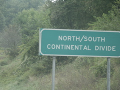
North/South Continental Divide. Presumably everything past this sign flows into the Great Lakes; everything prior to it flows into the Gulf of Mexico.

Overheads for US 20's departure from the bypass and approaching the Indiana Tol Road.

Overheads for I-80/90 and Nimitz Parkway.

Most of the US 20/31 bypass has been divided by a Jersey barrier. Here the median widens out just before reaching the toll road.

Overhead for the ramp to the Toll Road.

The exit gore sign is a little different than most. It doesn't say "exit."

Approaching the ticket booth at the entrance to the Indiana Toll Road.

Overheads where the exit ramp splits. Note the use of "Chicago" and "Ohio" as destinations rather than a city such as Toledo.

I-80 and I-90 markers mounted to supports for a speed limit sign.

Blue mileage markers on the toll road.

Button copy for the South Bend exit.

An IN 331 sign has been mounted on this exit sign.

At the end of the ramp from the toll road to IN 331.

The end of IN 331 at IN 23.

North IN 23 sign heading toward Michigan.

Entering Michigan.

The first M-62 sign.

Intersection of M-62 and US 12 at Edwardsburg. The meeting location was just to the right at the intersection.

An illuminated left-turn only sign on M-62.

Heading back into Indiana. Most of the signs are obscured by trees. The centermost sign is an IN 23 marker with an Indiana E-W Toll Road circular marker beneath it. At the right is a sign that says Entering St. Joseph County, Leaving Michigan.

Button copy sign for the Toll Road on IN 23 at IN 331.

IN 23 makes several turns in the South Bend area; this is one of them.

IN 23 passes under I-80/90.

Overheads in downtown South Bend.

More overheads.

Most of the banners for the old US 31 route through downtown South Bend have "Business" and "South" in one plate.

A shot of downtown South Bend.

A divided underpass.

Check out this old US 31 sign. You can tell that the US 31 marker, the "South" banner and the arrow are older and non-reflective by the yellowed appearance in contrast to the bright whites of the other signs.

A very old US 31 sign with an unusual shield shape and an old-timey font.

Older overhead for US 31.

This is another older overhead; it was seen in the distance in the previous photo.

Old signage for the end of the business route as it approaches the US 20/31 freeway.

A closeup of the old signage.

The context for the end signage. In the distance are the overheads for the US 20/30 interchange and the bridge itself can be seen in the background.

Butto copy overheads at US 31 southbound at US 20.

Typical view of US 31 southbound in the Lakeville area.

This is going south on US 31 at the US 6 intersection.

The first mention of the mileage to Indianapolis is south of US 6.

This is the split of US 31 north of Plymouth and its old routing.

Approaching US 30. Note the use of a normal-style US route shield with the black background. This happens in places in Indiana.

Button copy overheads on US 31 south.

DIfferent fonts at the US 31 and IN 10 intersection.

US 31 and Indiana 110.

IN 14 is closed for the overpass construction, so al ltraffic is detoured straignt on US 31 south.

Intersection of IN 25 and IN 114.

IN 25 and IN 16.

Additional signage at that intersection.

Typical view of IN 25 between Fulton and Logansport.

Overhead signage in downtown Logansport.

End signage for IN 17.

This is where the old routing of IN 29 south out of Logansport intersects the new alignment.

IN 18 and IN 29.

IN 18 and IN 29 signage with detour signage for IN 22.

Split of IN 18 and IN 29.

IN 26 crosses IN 29.

Approaching US 421 and the end of IN 29.

End signage for IN 29 at US 421 and IN 28.

Split of IN 28 and US 421.

IN 28 and US 421.

US 421 and IN 38.

US 421 and IN 47.

This church sits at the corner of IN 47 and US 421.

Closeup of the overheads at IN 47 and US 421.

IN 32 crosses US 421.

Indiana makes liberal use of these unmarked lanes. When there is no traffic turning left, through traffic uses the one that the white van is in. When traffic is turning left out of this lane, through traffic uses the right lane. This practice seems to be pretty common in Indiana.

Construction advisory sign for I-465 as US 421 approaches the Indy beltway. Note the use of "Northwest" instead of "North" or "West."

Oversized sign for IN 334.

Signage advising through traffic on US 421 to use I-465. US 421 emerges on the other side of town, after a hidden multiplex on I-465, at I-74.

Overheads where US 421 intersects I-465.

Overheads for I-865 and I-465.

"Major Moves" construction signage.

Overheads with a flashing caution light.

Wide view of the 465/865 interchange.

This overhead curve sign features a very narrow line.

Interesting red bridge support on I-465.

Overhead approaching I-65.

Overheads at I-465 and I-65.

Overhead for I-70 on I-65 downtown. Note that Columbus is the destination city while out on I-465, Dayton is used.

Overheads approaching I-70.

I-70 overheads.

At the exit to I-70. Note the right-aligned exit tab for a left exit.

Advance signage for the split of I-65 and I-70.

Getting closer to the I-65/I-70 split.

Two lanes in each direction for the split.

Split of I-65 and I-70.

Approaching I-465 on the south side of town.

East and West signage for I-465 and I-74.

Overhead mount with the same setup as before -- "Flat Rock" is not in button copy.