Interstate64

I-64 cuts across thenorth-central part of Kentucky, entering the state at Louisville. Itbegins at St. Louis and brings traffic from that city and Evansvilleacross southern Illinois and Indiana. After entering Kentucky, itgoes by the state capital city, Frankfort, before skirting the northside of Lexington. At Winchester, the route turns to the northeast.I-64 exits Kentucky south of Ashland and serves Huntington,Charleston and Beckley, W. Va., and Lexington, Charlottesville andRichmond, Va., before coming to an end in the Tidewater area of theOld Dominion State. Among the major routes I-64 intersects are I-44,I-55 and I-70 in Missouri, I-57 in Illinois, I-77 and I-79 in WestVirginia, and I-81 and I-95 in Virginia. In Kentucky, I-64 intersectsI-65,I-71, US 127, I-75,the MountainParkway, US 460 andUS 23.

I-264 is known as the Watterson Expressway (the western portion between this exit and US 31W / US 60 is sometimes called the Shawnee Expressway), and is the original bypass around downtown Louisville. It provides access to US 31W south, US 60 west, Churchill Downs, Standiford Field airport, Freedom Hall and the Kentucky Fair and Exposition Center, Kentucky Kingdom, and I-65 south (to Elizabethtown, Bowling Green and Nashville) before intersecting I-64 again on the east side of town. All major inbound highways intersect I-264 as it circles Louisville.

Exit 3

US 150 East

US 150

Exit 3

22nd Street

22nd Street

Simmons Bible College

US 150 used to follow an alignment with US 31W into Indiana on the old K&I Railroad bridge, before that span was closed to vehicular traffic and US 150 was routed onto I-64 to cross the river. This exit provides access to the western end of Louisville.

Exit 4

9th Street
Roy Wilkins Ave.

9th Street
Roy Wilkins Ave.

Exit 4

Downtown

Kentucky Arts Center
Convention Center
Science Museum

This is the primary downtown access point for eastbound traffic.

Exit 5A

I-65 South

I-65

Exit 5A

Nashville

Nashville
Indianapolis

Exit 5B

I-65 North

Third Street
River Road

Exit 5B

Indianapolis

Downtown

I-65 is one of two major north-south interstates in Kentucky (I-75, of course, being the other). Southbound I-65 offers additional access to downtown Louisville; northbound I-65 crosses the Ohio River into Jeffersonville, Ind. (Eastbound traffic should have used I-265 in Indiana as the through route to Indianapolis and I-264 as the direct connection for I-65 south; westbound traffic should have used I-264 or I-265 as the direct connection to south I-65 headed for E-town, Bowling Green or Nashville). Traffic heading west on I-64 must use this exit (Exit 5A) for I-65 north since the NIMBYs in the eastern part of Jefferson County are holding up progress on the East End Bridge that would link the Kentucky and Indiana segments of I-265. Westbound traffic can use the Third Street exit (Exit 5B) as an access point to downtown.

There is no connection for I-64 westbound traffic to hit I-71 north; traffic bound in that direction should use I-265 (Gene Snyder Freeway) or I-264 (Watterson Expressway) for I-71 north; there are no exits on I-71 between the two bypasses. I-71 parallels US 42 from Louisville, northeast through Cincinnati and Columbus, to Cleveland. In Kentucky, I-71 provides access to LaGrange and other Oldham County towns, Carrollton, Owenton (via KY 227) and Warsaw, before intersecting I-75 and remaining multiplexed with that major north-south route into Ohio.

Exit 7

Story Ave.
US 42 / US 60
Mellwood Ave.

Exit 7

If you are going to drive I-64 east through Kentucky and West Virginia, you are going to see several exits for US 60 as the miles pass. This is I-64's first interchange with US 60 as you're heading east; the last one as you're going west. Although US 60 is not labeled on the Story Avenue easbound exit sign, US 60 (along with US 42) are indeed routed on Story Avenue. These exits offer access to the eastern part of downtown Louisville; US 42 ends at US 31E (Main Street) just a few blocks west of these exits. Basically, from Louisville on to the Tidewater area of Virginia, I-64 and US 60 parallel one another.

Exit 8

Grinstead Drive

Grinstead Drive

Exit 8

Southern Baptist Seminary
Presbyterian Seminary

Southern Baptist Seminary
Presbyterian Seminary

Another exit allowing access to the eastern portion of downtown Louisville. Alternate US 60 intersects at the first traffic light south of this interchange.

Exit 10

Cannons Lane

Cannons Lane

Exit 10

Bowman Field Airport

Bowman Field Airport

Cannons Lane is KY 2048, but this is not noted on the exit signs. The route links Frankfort Avenue (US 60) (Shelbyville Road) to the north and Taylorsville Road (KY 155) to the south.

Exit 12A

I-264 West

I-264

Exit 12

Watterson Expressway

Watterson Expressway

Airport
St. Mathews

Churchill Downs

Exit 12B

I-264 East

Watterson Expressway

I-264 is the original bypass of Louisville; the Gene Snyder Freeway was added later. Built in the 1950s to carry US 60 traffic around Louisville, the Watterson has been extensively reconstructed in the past few years and now carries the I-264 designation exclusively (US 60 having been routed downtown again). For westbound traffic on I-64, I-264 west is the route to use to reach the airport and many of Louisville's attractions such as Freedom Hall and the fairgrounds, Churchill Downs, Kentucky Kingdom and Fort Knox. I-264 east leads to one of Louisville's major shopping areas at the Shelbyville Road interchange. All major inbound highways intersect I-264 as it circles Louisville.

Exit 15A

KY 1747 (Hurstbourne Parkway) South

KY 1747 (Hurstbourne Parkway)

Exit 15

Industrial Park
Jeffersontown

Jeffersontown
Middletown

University of Louisville Shelby Campus

Exit 15 B

KY 1747 South

Local Access

Exit 15 C

KY 1747 North

University of Louisville Shelby Campus
Middletown

This exit serves one of the fastest-growing areas of Louisville. Many services are located at this exit. Hurstbourne Parkway links Shelbyville (US 60) and Brownsboro (KY 22) roads to the north, and Taylorsville (KY 155) and Bardstown (US 31E / US 150) roads to the south.

Exit 17

Blankenbaker Road

Blankenbaker Road

Exit 17

Industrial Park

Industrial Park

McKendree College

McKendree College

This is a new interchange to serve a rapidly-expanding commercial area. Numerous restaurants and stores (including a Sam's Club) are located at this exit. Blankenbaker Road is shown as KY 913 on the official state map inset of Louisville.

Exit 19A

I-265 / KY 841 South

I-265 / KY 841 South

Exit 19A

Gene Snyder Freeway

Gene Snyder Freeway

Exit 19B

I-265 / KY 841 North

I-265 / KY 841 North

Exit 19B

Gene Snyder Freeway

Gene Snyder Freeway

Middletown

E.P. "Tom" Sawyer
State Park

E.P. "Tom" Sawyer
State Park

The Gene Snyder Freeway was originally built as the Jefferson Freeway, and carried only the KY 841 designation. When it was finally completed in the 1980s, the portion between I-65 and I-71 was given the I-265 designation. The entire highway links US 31W / US 60 in the southwestern part of Jefferson County and US 42 in the northeastern part of the county. Eventually (when the NIMBYs in eastern Jefferson County can be dealt with and the East End Bridge is built) the road will link with I-265 in Indiana, providing a bypass around three-quarters of the Louisville-Jeffersonville-New Albany downtown area. All major highways heading into Louisville intersect with the Gene Snyder, including I-65, US 31E / US 150, KY 155, US 60, KY 22 and I-71. Westbound traffic will find I-265 south to be an excellent shortcut to access I-65 south. The speed limit is 65 mph and traffic is much lighter than on the Watterson Expressway (I-264).

Exit 28

Veechdale Road

Veechdale Road

Exit 28

Simpsonville

Simpsonville

No indication is given on the exit signs, but this road is KY 1848. It leads to US 60 at Simpsonville.

Milepoint 28

Rest Area
Welcome Center

Rest Area

Milepoint 28

Just east of Exit 28, in Shelby County, are rest areas serving both directions of travel. The westbound rest area has been built for more than 30 years, while the eastbound rest area and welcome center was just opened in 1997. It replaces an older rest area which was located at the Shelby-Jefferson county line.

Exit 32A

KY 55 South

KY 55

Exit 32

Taylorsville

Shelbyville
Taylorsville

Finchville

Finchville

Taylorsville Lake
State Park

Taylorsville Lake
State Park

Exit 32B

KY 55 North

Shelbyville

Shelbyville
Historic District

KY 55 is a major north-south, nearly border-to-border highway through the central part of Kentucky. The northbound route serves Shelbyville (with access to LaGrange via KY 53 north), New Castle and Campbellsburg, and provides access to Eminence, Bedford and Carrollton, with access to US 421, I-71 and US 42 provided. Southbound, the route goes through Taylorsville, Bloomfield, Springfield, Lebanon, Campbellsville and Columbia. KY 55 intersects major routes such as the Blue Grass Parkway, US 150, US 68 and the Cumberland Parkway before ending at US 127 near Lake Cumberland.

Exit 35

KY 53

KY 53

Exit 35

Shelbyville

Shelbyville

Shelbyville
Historic District

KY 53 gives access to the east side of Shelbyville, including the new KY 55 bypass, and to all the towns served by KY 55 north. South KY 53 provides access to rural areas of Shelby, Spencer and Anderson counties and intersects KY 44 and the Blue Grass Parkway.

Milepoint 38

Weigh Station

Milepoint 38

Weigh stations for commercial trucks are located on both sides of the highway.

Exit 43

KY 395

KY 395

Exit 43

Waddy
Petytona

Waddy
Peytona

This is widely regarded as the halfway point between Louisville and Lexington. You'll hear a lot of references to "Waddy-Peytona" as if they are one village, but they are actually two separate communities. Peytona is north of this exit, at the intersection of KY 395 and US 60, while Waddy lies to the south. This route serves residents of eastern Shelby County.

Exit 48

KY 151, To US 127 South

KY 151

Exit 48

Graefenburg
Lawrenceburg

Graefenburg
Lawrenceburg

Wildlife Education Center

This exit offers a shortcut to Lawrenceburg. KY 151 intersects US 127 on the north side of Lawrenceburg, and the route links US 60 to the north and Lawrenceburg to the south.

Exit 53A

US 127 South

US 127 South

Exit 53A

Lawrenceburg

Lawrenceburg

Exit 53B

US 127 North

US 127 North

Exit 53B

Frankfort

Frankfort

Frankfort
Kentucky State Capital
Next 2 Exits

Kentucky State Capitol

Wildlife Education Center

Kentucky History Center

Kentucky State University

Kentucky State Police

Kentucky State Police

US 127 is another major north-south highway, and is in the process of being improved all the way from I-71 in the north to the Tennessee state line in the south. Here, taking the southbound exit leads to Lawrenceburg and the Blue Grass Parkway, then Harrodsburg, Danville, Liberty, Jamestown/Russell Springs and the Cumberland Parkway and Albany, before the route disappears into the Volunteer State. Right at the state line, at Static, TN 111 gives a modern highway link to I-40 at Cookeville. Northbound US 127 intersects Frankfort's East-West Connector (KY 676) and US 60, then skirts downtown and is multiplexed with US 421 for a couple of miles (where there is a directional disparity similar to that of I-77 and I-81 at Wytheville, Va.) before it goes north to Owenton and finally I-71. Those portions of US 127 which are not under improvement construction right now are on the books and scheduled for widening.

Exit 58

US 60

US 60

Exit 58

Frankfort
Versailles

Versailles
Frankfort

Frankfort
State Capital

Next 2 Exits

Kentucky History Center
Kentucky State University

US 60 between Frankfort and Lexington was one of the first four-lane roads in Kentucky. Reportedly, former Gov. A.B. "Happy" Chandler had the highway built to make it easier for him to drive from his home in Versailles to the state capital, and to Lexington. At one time, US 60 provided the through route for I-64 traffic before one of the last missing links of the highway, between this exit and I-75, was built. Now, it links Frankfort, Versailles, and the west and south sides of Lexington. US 60 intersects US 62 and the Blue Grass Parkway at Versailles, and passes by Keeneland and the Blue Grass Airport on its way to Lexington. NOTE: State and local police often patrol I-64 between Exit 58 and Exit 75. Motorists are well-advised to watch their speed in this area.

Milepoint 60

Rest Areas

Milepoint 60

Near mile marker 60, in Woodford County just east of the Franklin County line, are rest areas serving both directions of travel.

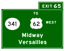
This exit provides access to Midway. US 62 and US 421 meet here, and are multiplexed for a few miles to the southeast, before they split again. US 62 west from Midway to Versailles is a Kentucky Scenic Byway and passes through some of the famed horse farms for which central Kentucky is known. Thru traffic heading east on US 62 can use I-64 between exits 65 and 69 for a quicker alternative route, but be wary of speed traps in this area.

Georgetown
College
Georgetown
College

A couple of miles south of here, US 62 and US 421 split. If you take US 62 north (the signs say "east" but the compass points north) you reach Georgetown, then US 62 continues to the northeast to Cynthiana. Westbound traffic on US 62 can use I-64 as a quicker alternative route to Midway.

Exit 75

I-75 North

Cincinnati

Kentucky Horse Park

I-75 is often called "Kentucky's Main Street." It is one of the major north-south roads in the United States, linking Michigan to Florida. Among the cities it serves are Detroit, Toledo, Dayton, Cincinnati, Knoxville, Chattanooga, Atlanta and Tampa. In Kentucky, it links cities such as Corbin, London, Richmond, Lexington, Georgetown and the northern Kentucky/metropolitan Cincinnati area. It intersects such important Kentucky highways as I-71, US 460 and KY 80. NOTE: Westbound motorists should keep a close eye for police officers, and an even closer eye on their speedometers, between this exit and Exit 58 at Frankfort.

I-64 and I-75 are multiplexed between I-75 Exit 118 and I-75 Exit 111, (I-64 Exit 75 eastbound and Exit 81 westbound) with the road maintaining I-75 mile markers and exit numbers. For exits on this stretch of highway, please refer to the I-75 guide.

I-75 South

Exit 81

Richmond
Knoxville

Lexington
Via US 60

I-75 is often called "Kentucky's Main Street." It is one of the major north-south roads in the United States, linking Michigan to Florida. Among the cities it serves are Detroit, Toledo, Dayton, Cincinnati, Knoxville, Chattanooga, Atlanta and Tampa. In Kentucky, it links cities such as Corbin, London, Richmond, Lexington, Georgetown and the northern Kentucky/metropolitan Cincinnati area. It intersects such important Kentucky highways as I-71, US 460 and KY 80. Access to Lexington can be obtained by taking Exit 81 to I-75 south, then by taking Exit 110 (US 60) or Exit 108 (Man O'War Blvd.).

Bluegrass Station is the collection of offices now located on the former site of the Lexington-Blue Grass Army Depot. This exit provides access to that facility. US 60 lies to the south; KY 57 is to the north at Avon, site of Bluegrass Station.

Exit 94

KY 1958 / Truck KY 627 South

KY 1958 / Truck KY 627 South

Exit 94

Van Meter Rd.
Winchester

Van Meter Rd.
Winchester

Fort Boonesborough
State Park

Fort Boonesborough
State Park

KY 1958 is the Winchester Bypass. Together with I-64 between exits 94 and 96, it is the truck route for KY 627 through traffic. Van Meter Road, a Clark County road, is just north of this exit, so in reality, Van Meter Road is a destination for this exit and is not the name of the highway which intersects I-64. Westbound I-64 truck traffic wishing to use KY 627 as a shortcut to I-75 should use this exit.

Exit 96

KY 627 / Truck KY 627 North

KY 627 South

Exit 96A

Winchester
Paris

Winchester

To Bert T. Combs
Mountain Parkway

Natural Bridge
State Resort Park

KY 627 North

Exit 96B

Paris

KY 627 used to be US 227. It is a major through route, and is a shortcut for westbound I-64 traffic to access southbound I-75, or for northbound I-75 traffic to access eastbound I-64. Westbound I-64 traffic (except trucks) wanting to bypass Lexington (and the endless I-75 construction between Lexington and Richmond) should use this exit and take KY 627 south to White Hall and I-75 at Exit 95. KY 627 north leads to Paris and US 27 (Cynthiana, Falmouth), US 68 (Carlisle) and US 460. Westbound I-64 traffic wishing to enter the Mountain Parkway, or westbound Mountain Parkway traffic wishing to use I-64 east, must use Exit 96A, then re-enter I-64 east.

Exit 98

Bert T. Combs Mountain Parkway

Campton
Prestonsburg

Clay City
Stanton

Natural Bridge
State Resort Park

This partial exit allows access only from I-64 eastbound, and traffic heading west on the Mountain Parkway can only enter I-64 west. The Mountain Parkway was Kentucky's second toll road, and has been vital in the economic development of eastern Kentucky. It provides access to many mountain towns, including Stanton, Beattyville, Booneville and Campton. At Campton, two two-lane extensions of the parkway split. The extension which still carries Mountain Parkway signage provides access to West Liberty, Salyersville, Paintsville, Prestonsburg and Pikeville. The extension signed as KY 15 leads to Jackson, Hazard, Hindman, Hyden and Whitesburg. Tolls were removed from this parkway in the mid-1980s. The Bert T. Combs designation was added in the early 1980s, to honor the mountain governor who had the vision to build the road.

Milepoint 98

Rest Area

Just east of the Mountain Parkway exit, a rest area serves eastbound traffic.

This exit, between Winchester and Mt. Sterling, provides access to I-64 from residents of eastern Clark and western Montgomery counties.

Rest Area

Milepoint 108

At milepoint 108, just west of Exit 110, a rest area serves westbound traffic.

US 460 / KY 11

Exit 110

Mt. Sterling
Paris

Two major routes, east-west US 460 and north-south KY 11, intersect at Mt. Sterling and are multiplexed at the I-64 interchange. KY 11 north goes to Sharpsburg, Bethel, Flemingsburg and Maysville. Southbound KY 11 goes to Clay City, where it offers access to the Mountain Parkway. US 460 west leads to North Middletown, Paris, and Georgetown (I-75). Eastbound US 460 is undergoing spot improvements and passes through Camargo, Jeffersonville and Frenchburg.

This US 60 exit is east of downtown Mt. Sterling. It provides access to the Mt. Sterling Bypass (KY 686) and also several new industrial parks.

Exit 121

KY 36

KY 36

Exit 121

Owingsville
Frenchburg

Frenchburg
Owingsville

KY 36 east from this exit passes to the east of Cave Run Lake and offers, via KY 211 and KY 1274, access to several recreation areas around the lake. The route ends at US 460 in Frenchburg. Westbound KY 36 passes through the hilltop town of Owingsville before continuing on to Sharpsburg (KY 11) and Carlisle. In Owingsville, KY 111 offers a scenic route to Flemingsburg.

Exit 123

US 60

US 60

Exit 123

Owingsville
Salt Lick

Salt Lick
Owingsville

Several Cave Run Lake recreation areas can be accessed by taking US 60 east to Salt Lick. Westbound US 60 climbs a hill and intersects KY 111, which is a scenic route to Flemingsburg, before entering Owingsville.

Exit 133

KY 801

KY 801

Exit 133

Sharkey
Farmers

Farmers
Sharkey

Daniel Boone
National Forest


Cave Run Lake

Daniel Boone
National Forest


Cave Run Lake

This is a new exit, built to provide direct access to Cave Run Lake. KY 801 has been improved to US 60 at Farmers, then on southward to the lake.

Exit 137

KY 32

KY 32

Exit 137

Flemingsburg
Morehead

Morehead
Flemingsburg

Morehead State University

Morehead State University

Kentucky Folk Art Center

Kentucky State Police

Kentucky State Police

Morehead is the intersection of I-64 and another major north-south corridor. Although KY 32 is signed as an east-west route, it basically follows a north-south path from Morehead to Flemingsburg. A corridor from KY 15 and the Mountain Parkway to Maysville is being developed, using KY 205, KY 519, KY 32 and KY 11. West KY 32 leads to Flemingsburg and Carlisle, with access to Maysville (and the AA Highway to Cincinnati) coming via KY 11 at Flemingsburg. Taking KY 32 through Morehead leads to Sandy Hook. KY 519 from Morehead leads south to West Liberty, where US 460 provides a route to Salyersville and Prestonsburg. From West Liberty, KY 205 south leads to the Mountain Parkway.

Milepoint 141

Rest Area

Milepoint 141

Rest areas serving both directions of travel can be found between Morehead and Olive Hill.

Milepoint 147

Weigh Station

Milepoint 147

Weigh stations for both directions of travel are located at the top of a hill between Morehead and Olive Hill.

Exit 156

To KY 59, KY 2

KY 2, To KY 59

Exit 156

Vanceburg
Olive Hill

Olive Hill
Vanceburg

From this exit, KY 2 runs south to Olive Hill, where it ends at US 60. Just north of this interchange, KY 59 branches from KY 2 and leads north to Vanceburg. KY 2 north provides access to Carter (a/k/a Carter City).

Exit 161

US 60

US 60

Exit 161

Olive Hill

Olive Hill

Carter Caves
State Resort Park

Carter Caves
State Resort Park

This exit is east of downtown Olive Hill. Taking US 60 west leads into town. It is not shown on the exit signs here, but US 60 is also multiplexed with KY 182. Following US 60 east, then following KY 182 east, leads to the state park.

Exit 172

KY 1 / KY 7
To AA Highway / KY 9

KY 1 / KY 7
To AA Highway / KY 9

Exit 172

Maysville
Grayson

Grayson
Maysville

Vanceburg

Vanceburg

Greenbo Lake
State Resort Park


Grayson Lake State Park

Greenbo Lake
State Resort Park


Grayson Lake State Park

Kentucky Christian College

Just recently, signs have been erected at this interchange, listing Maysville and Vanceburg as destinations, and noting the access to KY 9 and the Ashland-to-Alexandria Highway. A number of destinations can be reached from this exit. KY 7 leads south from Grayson to Sandy Hook and West Liberty. Plans are on the books to improve the KY 7 corridor to allow a high-speed access route to the Mountain Parkway. Work is already done from the parkway to West Liberty; but has not yet begun north of West Liberty. KY 1 south offers a winding route to Fallsburg and Louisa. KY 1 north heads to Greenup and US 23; KY 7 north also leads to US 23 though in a more roundabout way. Just north of this interchange, KY 9 (AA Highway) ends. This route leads to Vanceburg, Maysville, and on west to the Cincinnati area. It is the preferred route for through Ashland-to-Cincinnati traffic as it saves much time and considerable mileage over the I-64 to I-75 route through Lexington. IMHO Cincinnati should have been listed as a destination for the AA Highway. The section between Grayson and Exit 181 was one of the last ones completed in Kentucky; for years traffic had to use US 60.

Milepoint 173

Rest Area

Rest Area
Welcome Center

Milepoint 173

Rest areas serve both directions of travel, just east of the Little Sandy River bridge and the Grayson interchange. The westbound rest area is the welcome center for traffic entering Kentucky from West Virginia.

Exit 179
Exit 179
KY 67
KY 67
Industrial
Parkway
Industrial
Parkway
Open to KY 207
Open to KY 207

This new exit opened in October 1999. Currently, the route is only approximately 2 1/2 miles long, and serves a planned industrial park near the spot where Carter, Boyd and Greenup counties meet. Eventually, KY 67 will extend to US 23 near Greenup, providing an alternate route to Greenup, South Shore and Portsmouth, Ohio (and points north), bypassing downtown Ashland.

Exit 181

US 60
US 60

Exit 181

Many years ago, I-64 westbound ended at this exit, and all traffic between this exit and Grayson had to use US 60. Now, this traffic leads to communities in the area such as Rush and Princess. US 60 east does provide another access route to Ashland.

Exit 185

KY 180

KY 180

Exit 185

Cannonsburg
Ashland

Cannonsburg
Ashland

Kentucky State Police

Kentucky State Police

Paramount Arts Center

Paramount Arts Center

Ashland
Next 2 Exits

This is the main Ashland exit for eastbound traffic. Just north of this exit, KY 180 intersects US 60, which leads to downtown Ashland.

Exit 191

US 23

US 23

Exit 191

Ashland
Louisa

Louisa
Ashland

Ashland
Next 2 Exits

Catlettsburg

Catlettsburg

US 23 is also Appalachian Corridor B, a vital north-south link through the mountains and one of the major N-S routes in all of Kentucky. When a construction projects in North Carolina is complete, it will be four lanes all the way from south of Asheville, N.C., to north of Columbus, Ohio. US 23 southbound leads to Louisa, Paintsville, Inez, Prestonsburg, Pikeville, Jenkins, Whitesburg, Norton, Va., Kingsport and Johnson City, Tenn., and eventually Asheville. North US 23 passes through Ashland and Greenup before crossing the Ohio River at South Shore and passing through Portsmouth on its way to Columbus.

Backto Guide to Kentucky's Interstates andParkways
GoBack to H.B.'s Roads Page
GoBack to H.B.'s Millennium Highway

Thispage created June 4, 1998
Last modified Oct. 27, 1999
Special thanks to Scott Oglesby and the
KurumiSignmakerfor the replica signs
© 1998, H.B. Elkins